Engineering companies and consultants with energy management expertise are advising local authorities on their energy transition plans as they move away from fossil fuel based technologies to cleaner and more sustainable renewable energy sources.
Under the FIT-for-55 package from the European Commission, local authorities with 50,000 inhabitants or more are strongly advised to create an energy transition plan and in Germany these plans are now mandatory for municipalities. Such a transition plan includes a feasibility study to analyze the technical and economic viability of a district heating network before proceeding to the next steps of detailed design and construction. District energy networks are a viable solution for many communities and there is growing interest in practical deployment strategies.
The approach to feasibility studies
Engineering consultancy companies that are carrying out these feasibility studies typically have highly skilled engineers with expert domain knowledge and are developing valuable inhouse methodologies. However, they are also often burdened by legacy processes involving paper maps and spreadsheet models. Those who have more resources might use open source digital geospatial tools like Google Earth and QGIS or applications like ArcGIS to manually plot the network topology. This approach often involves entirely separate technical and financial modeling that might be cobbled together with custom visual basic or python software programs.
Unfortunately, this traditional siloed approach doesn’t provide the consistent level of detail, accuracy, and quality output that local authorities require to make high-profile investment decisions on major district energy schemes.
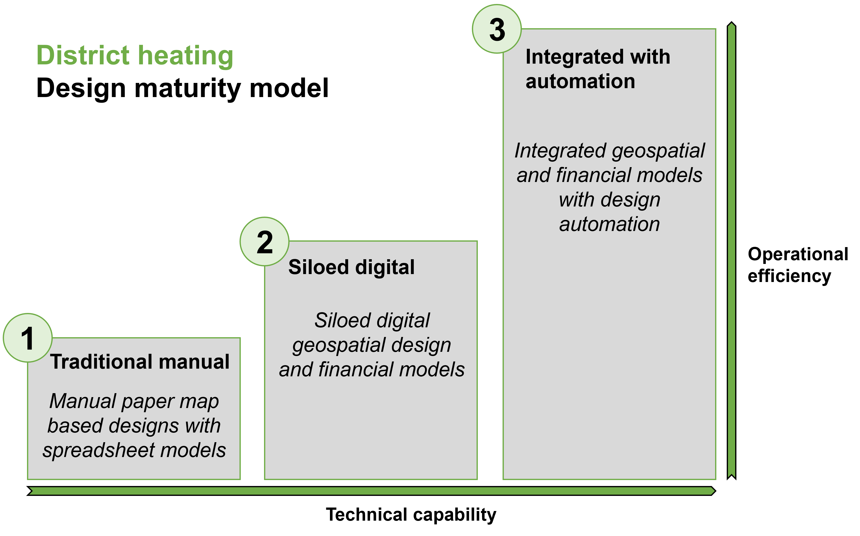
The three levels of district energy network design maturity
Working with design partners in the deployment and use of our Comsof Heat planning software, we’ve learned how important it is to manage this challenge and deliver the high-quality techno-economic feasibility research essential for local authorities. The design approach of engineering companies today typically falls into one of three distinct levels of maturity:
Level 1: Traditional manual paper map based design with spreadsheet models
Level 2: Siloed digital geospatial design and financial models
Level 3: Integrated geospatial and financial models with design automation
The goal for an energy transition consultant should be to reach Level 3 maturity in order to efficiently create robust, high-level CAPEX feasibility estimates that contain the essential detail to withstand rigorous public and private scrutiny.
Additionally, the outputs should support the consultant’s report across a range of key areas:
• Generate reliable capital cost numbers
• Identify detailed material insights with a comprehensive bill of materials
• Document potential revenue and return on investment
• Provide digital map visualization for large areas across the grid
• Deliver costed network deployments over multiple project phases
So, how do these maturity levels differ and why should a consultant strive for Level 3?
Level 1 maturity model describes when consultants have the expertise and skills to create techno-economic analysis but they are making mainly manual calculations that are not joined up with other processes. In Level 1, consultants know the physics needed to dimension the pipe systems, and create spreadsheet based models of the network to size the pipes, calculate pressure parameters and network losses. These numbers are usually based on rough estimates of distances and resulting networks are drawn by hand on paper maps.
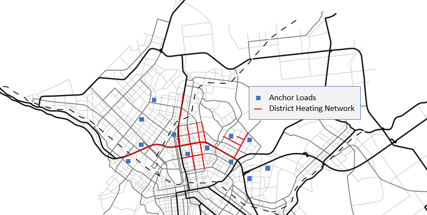
The process is slow, inaccurate, labor intensive and not scalable to large areas. Typically this approach can work for a network with a few anchor loads, practically not much more than 25-30, but unmanageable for larger residential and commercial networks. Because the process is time consuming, typically only one district heating scheme can be analyzed since making calculations for multiple scenarios is impractical. The results are relevant in those cases where a high level estimate is sufficient only to get an initial indication of deployment costs.
Consultants eventually reach a point where they realize they need a better solution to fully address business modeling requirements. For example, clients frequently expect geospatial views to assess the impact of the construction works and need accurate costing models that includes comparisons different scenarios that assess network risks.
Level 2: Siloed digital
Level 2 maturity is achieved when consultants graduate from spreadsheets and paper maps to dynamic spreadsheets and geospatial tools, but these digital tools are not joined up and the processes remain siloed. The spreadsheets can include additional programming to dimension pipe diameters in the network, and the geospatial tools can be enhanced with in house developed Python code for basic input data processing or GIS modelling. Although the process is still time consuming, it offers opportunities to analyze multiple scenarios and support somewhat larger planning areas.
The networks designed with this approach can be small distribution or transport networks with distribution points as end points. Drawing the transport network by hand is still possible while it is too time consuming to draw the pipe designs for the distribution networks. Using this approach, buildings are typically clustered by hand around the distribution points and the distribution network is not further detailed. The financial model is disconnected from the geospatial model, often employing a separate spreadsheet to calculate the deployment costs. The transport network length is known approximately, however, costs for the distribution connections are based on fixed costs per building.
The level of accuracy and the scale of networks which can be designed with this approach is improved compared to Level 1 but the process is still time consuming, labor intensive, not very accurate, and error prone. Additionally, typically only one expert engineer in the team, who developed the model, is capable of using the tool because of its complexity, and these tools are notoriously difficult to maintain and enhance when multiple projects are being run in parallel. This means that this siloed approach does not scale as the number of projects or scenarios increases since the technical calculation will remain a bottleneck in the process.
The takeaway is that consultants who have reached this level have the knowledge and skills in house to execute successful small and large scale projects but have to decline additional work because of fundamental operational bottlenecks caused by a lack of software automation. This prevents companies from scaling up their business and differentiating their services with additional scenario analytics.
Level 3: Integrated with automation
Consultants in Level 3 have an integrated solution where the geospatial model, the technical model and the financial model are tightly interconnected. These models are integrated within a GIS application and includes design automation.
Automation of process and teams also facilitates manual fine tuning and discussions, and makes it easy for development, technical, and executive teams to compare different energy strategies without compromising detail. This means that the model can now be used as part of the zoning exercise to provide design insight applied into feasibility, planning and financial models. Swift and accurate scenarios can be built based on GIS and energy data, local knowledge, and shaped based on basic technical parameters.
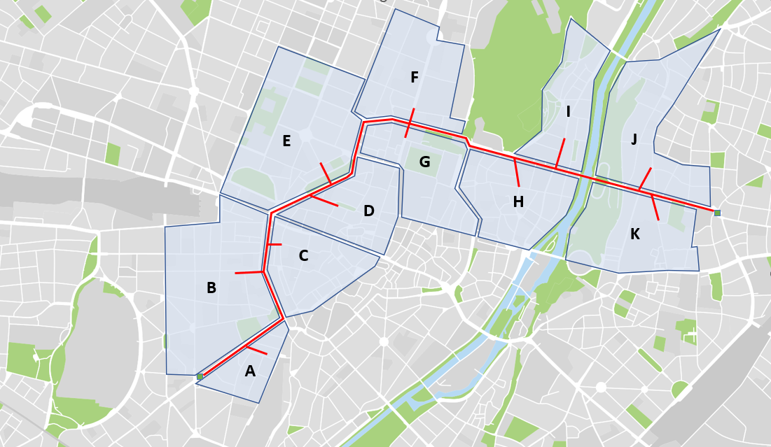
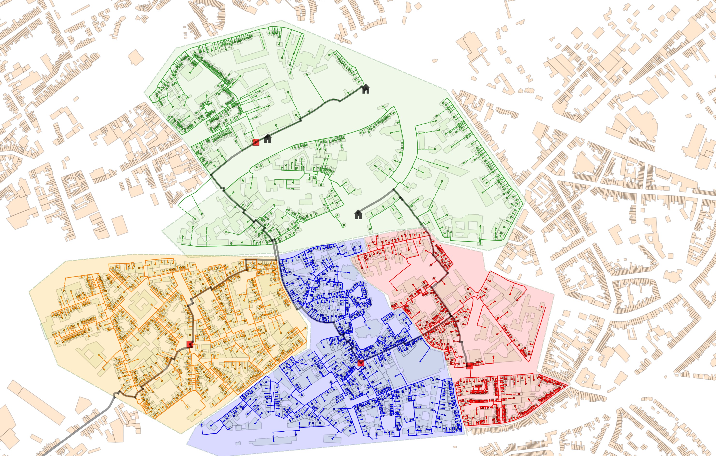
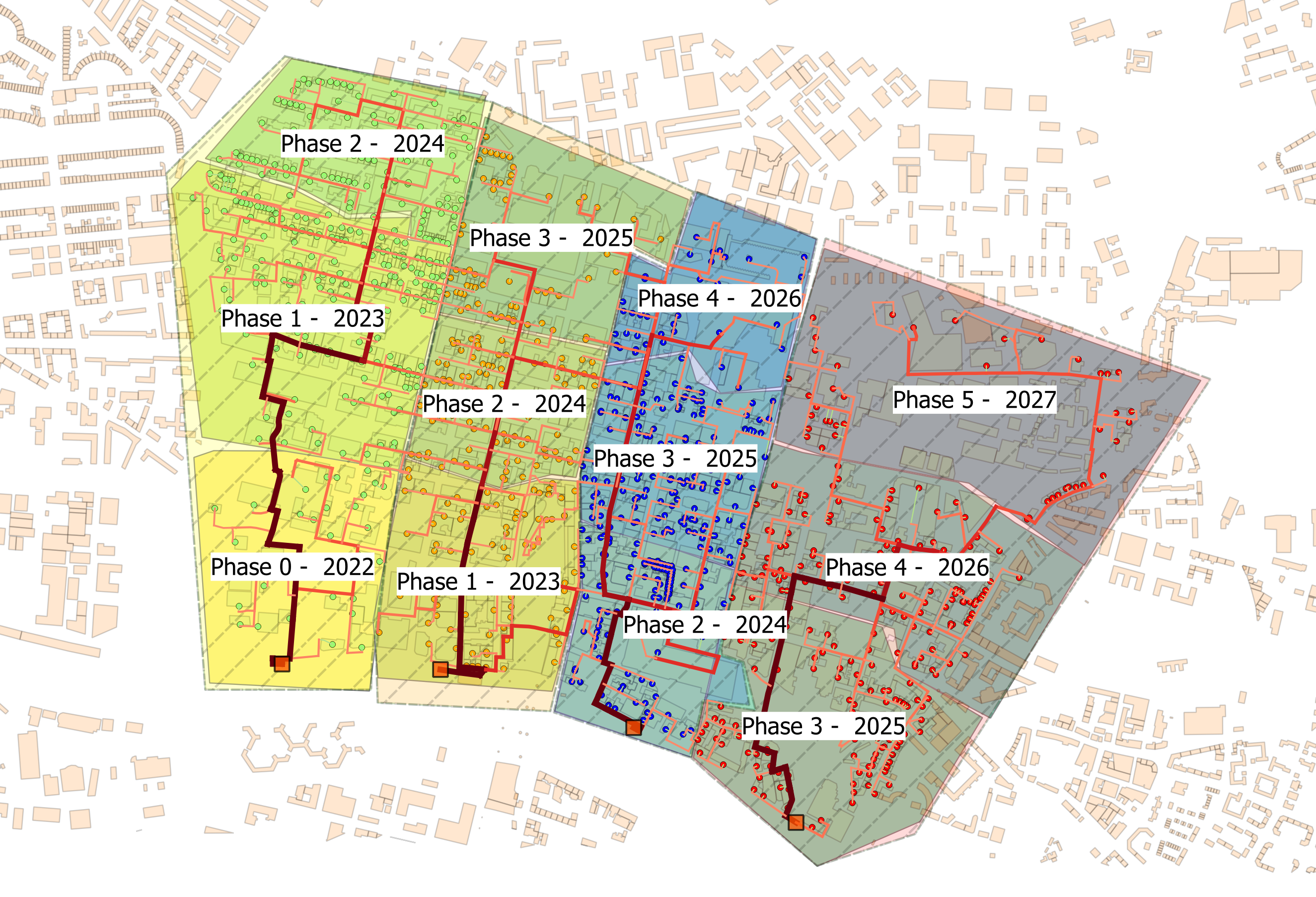
This Level 3 integrated approach provides extensive planning and design capabilities for district heating network designers. A business case can be built, accompanied by a bill of materials, network visualization, scenario comparisons, and a rollout timeline.
Higher quality, more valuable modeling can be delivered. The software dimensions the network pipe system and a bill of materials, provided in a spreadsheet, with a comprehensive overview of all pipe system lengths and network deployment costs. Network roll-out stages and different heat tariffs can be defined to calculate heat sales revenues and, generate a financial evaluation report of the project over its lifetime for decades to come.
Business benefits to Level 3 maturity
Achieving Level 3 maturity is an absolute necessity for companies hoping to scale up their business and services. It enables them to target higher margin projects with larger scopes (city scale sized studies) and greater complexity. The integrated approach also offers much greater overall process productivity since modelling can generate more accurate and complex results with less manual manpower. The process is highly scalable and the results generated by different network designers are more consistent and uniform, reducing downstream network maintenance costs.
With our existing Comsof Heat customers and partners, we’ve seen how Level 3 maturity can reduce design and study time from weeks to days, while taking a consultancy business to an entirely new level of operational efficiency. Now is the time for consultants and communities to step up their game and deliver the designs and analytics essential to meet the enormous and exciting challenge of our energy transition.
DESNZ has issued a tender for Heat Network Zoning and IQGeo can support any consultancy with Comsof Heat.
The approach with Comsof Heat offers significant advantages in the development and optimization of the initial zoning opportunity's (IZO’s). Using Comsof Heat enables consultancies to provide a consistent level of detail, accuracy, and quality output over all IZO’s, underpinning DESNZ requirement to implement a standardized heat network zoning methodology. Using an automated routing, dimensioning and planning tool enables an integrated solution where the geospatial model, the technical model and the financial model are tightly interconnected, integrated within a GIS application. Doing so enables a consistent and precise estimation of the required heat capacity and distribution infrastructure, minimizing the risk of overinvestment or underestimation.
Contact Kurt Marlein to discuss partnering with IQGeo and utilizing Comsof Heat for the UK Heat Network Zoning project.

Former Product Manager at IQGeo
Similar articles:

 Previous


